In August 2011 I went to Sweden, Finland, Estonia, Latvia, and Lithuania for almost 3 weeks. Most of my time (about 10 days) was spent in visiting the central part of Sweden. Since I had seen Stockholm a couple times and also southern Sweden, I figured I would focus on central Sweden now and work my way up to the north of Sweden for a later trip. But since I cashed in air miles, the best I could do was to get to Helsinki, Finland. Since I was in Helsinki, I thought I would include a layover of a couple days (even though I had been there twice before). Then from Helsinki I would fly to Estonia and drive south to Latvia and Lithuania for the 8 remaining days before returning to Helsinki to fly home. This trip may seem a little disjointed, but, stick with me, it made sense in my head when I booked the flights between the cities.
Once I landed in Stockholm, Sweden I spent a couple days seeing the sights. Stockholm proper is composed of 14 islands and is often referred to as ‘The Venice of the North’. Despite the islands, you can still get around relatively quickly to see the sights. Stockholm center is composed of several different areas. The Gamla Stan (Old Town) area is an island to itself and has remnants going as far back as the 13th century. Strolling along Västerlånggatan (The Western Old Street) places you in the heart of the old town. Included in this area is the Kungliga slottet (Royal Palace), where I was able to see the changing of the guard. Adjoining is The City area, which is more modern, from the 18th century. The City includes many museums, theaters, and shopping areas. The landmark here is the 131 metre (429 feet) Glass obelisk Crystal in Sergels torg (Sergel's Square). To feel like you are not in a big city, the Blasieholmen and Skeppsholmen areas, connected by the 165 metre (541 feet) Skeppsholmsbron (Skeppsholm Bridge) takes you to a quiet part of Stockholm with museums, restaurants, and nature.
But is doesn’t just end there. Just around these central areas there is still a lot of Stockholm to see within easy reach. The Vasamuseet (Vasa Museum) houses the salvaged warship Vasa that capsized in Stockholm’s harbor in 1628 (recovered in 1961). Skansen is the world’s first open air museum (1891), with 150 buildings it is a town within a town (I love the open air museums, but you knew that). The iconic Stadshuset (City Hall) has become the symbol of Stockholm and hosts the annual Nobel Peace Prize ceremony. Fjällgatan is a picturesque cobblestone street with houses from the 1700s, but more impressive are the panoramic views over the city and water. Speaking of water, don’t forget to use the ferries to get around the city or just take a short cruise through the Stockholm Archipelago to get a different perspective of the surrounding area. There is a lot to do just in Stockholm. But, I have been here before and I will be back, so I’m moving on to the central part of Sweden.
I’m calling this the central part of Sweden tour, but if you look at a map of Sweden, there is a lot more north of Stockholm then there is south. I guess I consider Stockholm the center of the country (even though it is nowhere near the center of anything in Sweden). So for you map aficionados and those who just know everything there is to know about Sweden, I am going to use the historical region names of Sweden and will therefore be traveling within the Svealand region of Sweden. This is the middle, since north of Svealand is the region known as Norrland and south of Svealand is the region known as Gotland. It will hence forth be referred to as the middle part of Sweden tour (Svealand). Well, I am certainly glad we cleared that up.
Since the middle part of Sweden (still with me?) is considered the historical core of Sweden, there are a lot of historical things to see. In Mariefred, Sweden the Gripsholms slott (Gripsholm Castle) from 1526 sits majestically on Lake Mälaren just across from the old town. In Strängnäs, Sweden the 12th century Strängnäs domkyrka (Strängnäs Cathedral) commands a spectacular view over the town.
The town of Örebro, Sweden has many sites, including the River Svartån winding through the town. The Rådhuset (Town Hall), though only built in 1860 has a classical style to it. Dominating over one end of the Stortorget Square, is the tower of St. Nicolai Kyrka (church). Straddling the River Svartån is Stadsparken (City Park) and the Wadköping open air museum with its wooden houses and town like setting. The most famous landmark has to be the Örebro Slott (Castle), virtually in the middle of the river and beautiful, but small, garden.
The small town of Nora, Sweden just sounded nice when I read about it – ‘colorful wooden houses and cobblestone streets’. They say these are the best preserved houses in Sweden from the 18th century. Even though it was a little out of the way, it was on a scenic route in the direction I was heading anyway. Besides the quaint houses, it also had a Train Station restored with some antique rail cars (Nora had Sweden’s first normal gauge railway). The town was also on Norasjon (Nora Lake), with a promenade that was along the waterfront. Sometimes you find a nice out of the way place that deserves to be written up, even though there was technically nothing to do here. Besides, nothing to do is sometimes the best thing to do.
Karlskoga, Sweden has the Nobelmuseet (Nobel Museum) in Alfred Nobel’s last home he lived in, showcasing his life. Not far from here Kristinehamn, Sweden’s claim to fame is a statue designed by (but not crafted by) Picasso. I think they should stick with their backup claim to fame – Kristinehamn is located exactly in the middle of Oslo, Stockholm and Gothenburg. Karlstad, Sweden is the furthest east I will be going on this journey. The best part of Karlstad is the nature around that area. A well known landmark of the town is the 12 arch stone Östra bron (East Bridge), which I guess is so the people can escape town and enjoy the nature (I just remember this is where I bought Rabarberflarn (Rhubarb cookies), yum).
Up to this point, these locations have been, for the most part, directly west of Stockholm. Now I’m driving a bit north to see some sites but will still be in Svealand. The town of Mora, Sweden is located between the northern shore of Lake Siljan and the southern shore of Lake Orsasjön in a very scenic setting. The town itself is not old in the sense of historical buildings, but it was designed and built to be a very beautiful town and worth seeing. Not far from here are 2 attractions. In Nusnäs, Sweden the national symbols of Sweden are made here, the Dala horses, in several small shops. I actually purchased a Dala horse that is rough carved and unpainted, something you would only be able to buy here. Also nearby in Sollerön, Sweden is Tomteland. I’m not quite sure how this phrase translates, but suffice to say this is Santa’s World. They have several buildings, animals, restaurants, Santa’s home, and even his sleigh (it was up on blocks for the summer). Though generally geared toward children, I thought it was neat. What I can say, that’s just my mentality.
OK, I hope I’m not going to throw you off-course now. I will be leaving Svealand for a short time just to go see Gävle, Sweden in Norrland (you remember where that is, north of Svealand?). I did this since it was on the way back toward Stockholm and it looked like a nice town, on the Gävleån River. Despite a fire in 1869 that destroyed a lot of the town, the Town Hall building from 1790 and Heliga Trefaldighets kyrka (Holy Trinity Church) from 1654 still stand. Most of the town has charming 19th century buildings, but because of growth there are also modern buildings. The highlight of Gävle is the 16th century Gävle Slott (Castle) and the surrounding Gamla Gefle (Old Town) with its 18th century wooden houses and streets. Now back into Svealand and a few sights just outside of Stockholm.
Just north of Stockholm is the city of Uppsala, Sweden. Even though it is big (the 4th largest city in Sweden), there were still a couple things to see related to the history. The beautiful Domkyrkan (Uppsala Cathedral) is as tall as it is long, 119 metres (390 feet), thanks to its 2 spires reaching into the sky. The 16th century Uppsala Slott (Castle) stands high on a ridge over the city and affords great views. Nearby in Sigtuna, Sweden are several stately castles from the 17th century worth viewing, including Skokloster, Steninge, and Rosersburg (actually a royal palace).
Just south of Stockholm is ‘the end of the world’. Well, that’s what the locals call Trosa, Sweden. It is a town on the Trosa River and on the archipelago, where the road ends. It is a really pretty pedestrian town with small streets, colorful buildings, and of course the water. ABBA's Benny Andersson and Björn Ulvaeus (that would be the B and the B), have summer homes in Trosa. And on that (musical) note, it’s back to Stockholm to catch my flight to Helsinki.
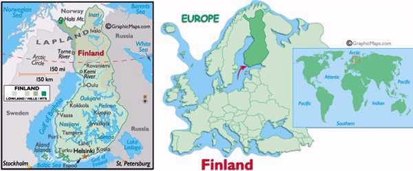
From the Helsinki airport, you can easily catch a couple different buses to the Central Station. The FinnAir bus is an express bus to Central Station. The city buses take a while longer, but are a little cheaper. They are planning on completing a train from the airport to the Central Station in the near future. Once at the Central Station, Helsinki is an easy town to get around (it is in the town center after all). My favorite area is near the Market Square next to the Port. They always seem to have outdoor stands that include a wide variety of food and other items of interest. Just off the square is Esplanadi Park, which is a nice walk toward a number of shopping streets and malls nearby. Helsinki is a really pleasant city to be in. After a few days in Helsinki, I needed to get to Estonia. I could have taken a ferry across the Gulf of Finland - been there, done that. But instead, I did a quick flight from Helsinki to Tallinn, Estonia.
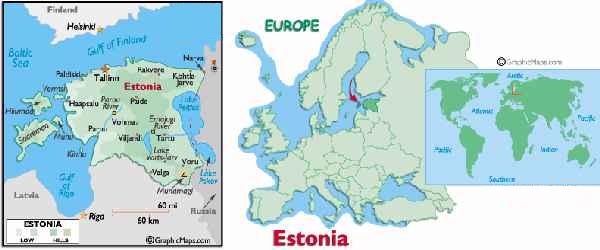
When I was in Tallinn, Estonia back in 2007 I thought it was a very beautiful city and I wanted to see the rest of the country on another trip. So I’m back for more. When I was in Tallinn this time I had a celebrity sighting. I saw the (then) current President of Estonia Toomas Hendrik Ilves and also the former Prime Minister Mart Laar (picture is below). I happened to be there on the 20th anniversary of Estonia Independence Restoration Day. They had a massive free music event, ‘Song of Freedom’, with a carnival like atmosphere held in the Lauluväljak (Tallinn Song Festival Grounds). Ironically, this day was called ‘Islandi Päev’ (‘Iceland Day’) as a tribute to Iceland since Iceland was the first country to recognize the restoration of Estonia’s independence in 1991. Tallinn is definitely worth seeing (once again, it did not disappoint). I did some reading up on Estonia ahead of this trip to find highlights of other places I might like to see besides Tallinn. I found several sights in Estonia (Haapsalu, Rakvere, Ontika, Narva, and others), but time did not allow me to drive there on this trip (definitely another trip when I return again to Tallinn). So the remaining point of interest I had driving south in Estonia to Latvia was the town of Pärnu. Pärnu has a great historic district with many colorfully painted wooden buildings. The old town is centered on Rüütli tänav (Knight Street). It definitely has a charm that requires you to be immersed in. So now I’m on my way to Latvia.
But first… Now it’s time for a quick and painless geography lesson. You always hear people say ‘There will be a test later’, well this time it’s true. Everyone knows where Estonia is, right? So, we will use that as our base. But, everyone gets confused between Latvia and Lithuania. Which is which and where are they located. My easy to learn method is to remember Latvia is below Estonia, and Lithuania is below Latvia. So it’s alphabetical from the top to bottom – Estonia, Latvia, and Lithuania. You can thank me later when this question comes up on the million dollar question.
When I crossed the border from Estonia to Latvia, the border crossing structures were all still in place, but abandoned. It was a bit weird to see since it was reminiscent of an earlier period (guard towers and all). It was December 21st, 2007 when all border crossing points were opened between the two countries and both countries joined the Schengen Agreement.
Rīga is the capital and largest city in Latvia (about 700,000 people), and over 1/3 of the Latvian population lives in or near the city. It was founded in 1201 thanks in part to it being on the River Daugava joining with the Gulf of Rīga and the Baltic Sea. While sightseeing, most of what you would want to see is centrally located in the old town and near the River Daugava by walking, but the city does have a very good bus and tram network. Near the Town Hall Square, there are several beautiful buildings (although many reconstructed, they still hold their charm – if you’ve been to Frankfurt, Germany old town then you know what I mean). The iconic House of Blackheads and adjoining Schwab House are Rīga’s most recognizable (OK, maybe only if you know anything about Latvia). These former guild houses now house a concert hall and the tourist office. Just behind the square stands the 123 metre (403 feet) St. Peter’s Church. The view from the Church’s observation deck over the city at 72 metres (236 feet) is spectacular (and yes, there is an elevator). A short walk from the square is the Central Market, 5 huge Zeppelin hangers from WWI that house a market with anything you would want to buy. Most of the items are fresh items (fruit, vegetables, flowers, meats, fish), but there is so much here it even spills out into the surrounding areas around the hangers. It is well worth seeing if only to be in awe over the size. Wandering the streets around the old town, you will see a lot more historical looking buildings. I also suggest just off the square to wonder down Kaļķu iela (it’s a street) for many of the restaurants available and continue strolling to the Freedom Monument. Overall, Rīga was very pretty, easy to get around, and had a whole lot to see.
Here’s where it got confusing. I was looking for Jūrmala, since it was supposed to be a nice beach along the Gulf of Rīga. What I eventually figured out was that it is really a region along the Gulf and encompassed a whole bunch of beaches and towns (kind of like the Beaches of Normandy). Jūrmala actually means ‘seaside’ in Latvian (stick that in your fortune cookie). Once I figured that out I just stopped at a couple beaches and roamed a few towns to get the feel. The most popular of these areas was Majori Beach, I found that’s where the action was.
The beautiful Rundāles pils (Rundāle Palace) is located in an area known as Pilsrundāle. Built around 1750, over the past 30 years most of the rooms have been restored, as well as the outside. The French style gardens have been restored to their original plans. Not far away, in the small town of Bauska, restoration is taking place on the 15th century Bauskas Pils (Bauska Castle). Built at the confluence of the Mūsa and Mēmele Rivers where they form the Lielupe River, this is an idyllic setting for fairs and festivals held often at this castle.
Time to cross into Lithuania. No surprises here, just a couple signs to indicate the border and a few quick pictures. Unlike Estonia or Latvia, Lithuania is a bit backwards. But, only in the respect that the country’s capital city of Vilnius is located in the far reaches of the country from where I crossed the Lithuanian border. So I need to do some sightseeing in the countryside, before heading to the big city lights in the capital of Vilnius. We’ll wrap up the trip there.
Šiauliai, Lithuania is the 4th largest city in the country. After WWI, about 85% of the city was destroyed and rebuilt. It didn’t fair much better in WWII with about 80% of the buildings being destroyed. Since then, the city has come back and rebuilt to be a thriving city for Lithuania. Surprisingly, the Cathedral of Sts. Peter and Paul still stands from 1625. Just outside the city is an amazing site that can’t be explained (although it might explain why the Cathedral survived both World Wars). The Kryžių kalnas (Hill of Crosses) is a Pilgrimage site where people leave crosses, crucifixes, and rosaries for no apparent reason. It started in 1831, and numerous attempts by various groups and governments have tried to squash it, but to no avail. The crosses have continuously appeared. Sometime in the 1980’s it was left alone and it continues growing to this day. On September 7, 1993, Pope John Paul II visited the Hill of Crosses, declaring it a place for hope, peace, love and sacrifice. You have to see it yourself since the pictures don’t really provide an authentic feel of the vastness of the hill (can you say hoarder?).
Fun fact - Kaunas, Lithuania is the 2nd largest city in Lithuania. This you did not know, admit it. It is located at the confluence of the Nemunas and Neris Rivers (the city, literally, comes to a point where the rivers meet). Amazingly, the old town is extremely well preserved and has a lot to offer. The Old Town Hall in Old Town Square resembles a church, and was built in the 16th century. Oddly enough, just off the square is the Church of the Holy Trinity which looks more fort like then church like with its thick stone walls and towers. Since Kaunas had a prime location on the rivers, it goes without saying the city had a castle – Kaunas Castle. Originally built in the 13th century, today it is primarily in ruins but has some restoration done. It didn’t hold up well over the centuries with invasions from the Russians, Swedes, and French. So on to another castle of a different kind.
Trakai, Lithuania is a popular tourist destination for the residents of nearby Vilnius. Not so much the town itself (there are only about 5000 residents), but all the surrounding area with parks, forests and lakes. For me, the draw was the 14th century Trakų salos pilis (Trakai Island Castle). That’s right, a castle, and an island. How cool is that? They have a long wooden footbridge connecting the island to the mainland. Once on the island, you can walk all around the shore on the outside of the castle and go inside to see the structure, which includes a history museum.
Purnuškes, Lithuania is the closest town near the Center of Europe. Located just north of Vilnius, there is some controversy of this being the Center of Europe. It depends on how you define Europe and if you include islands for some countries. It has been said the center is in Estonia, Hungary, Belarus, Poland, Germany, Slovakia, and the Ukraine. Some of these locations even went so far as to create a monument or marker. However, according to the Guinness Book of World Records, the official center is this one in Lithuania. So I’ll go with that until I get to the others and get a photo there. The Lithuanian center of Europe has a large monument there and even provides nice certificates, suitable for framing, affirming this as the center. Neato!
So heading a little off-center (some Center of Europe humor), I’m on to Vilnius, the capital and largest city in Lithuania (about 520,000 people). The old town is one of the largest in Europe, yet it is still compact enough to see in a day. Most places of interest are between Cathedral Square and the Gates of Dawn (the only surviving city wall gate remaining from the 16th century). The main street (actually a series of streets) connect these 2 locations. I call it the main street, but you just have to know you’re in the old town and everything will be fine. Trust me, you’ll see. There are some sights in the old town, just a few blocks off the main street, so roam around and find them. I was surprised by how many regal or royal looking buildings there were. The Vilnius Cathedral is from the 18th century and has a classic Baroque style, with the free standing Bell Tower adding extra visual charm. Also near here are the Upper and Lower Castles. It is well worth the walk to the Upper Castle to see a panoramic view of the city (OK, there is a funicular, but walk the hill and enjoy the peaceful park setting). Heading up the main street, you will have to veer off a bit to see the 14th century Presidential Palace. But, don’t expect to get too near to the actual building. It is definitely worth wandering off the main street. There are a lot of churches with a wide array of styles over the centuries, too many to mention here. OK, now the method to my madness about roaming around the old town. I have to admit, this was probably the best city ever for tourist signage (in Lithuanian and English). If you saw something that looked interesting, they had a sign telling about it. Additionally, they also had great sign-posts pointing in the direction to the sights. This is so nice to see. So like I said, don’t worry about wandering off the main street since you will always be able to get back.
Speaking of getting back. Time to get back to Helsinki to catch my flight home. From here Helsinki seems a world away, but actually it is only 4 countries away.


 top
top